Streaming service - メーカー・企業45社の製品一覧とランキング

更新日: 集計期間:Sep 24, 2025~Oct 21, 2025
※当サイトの各ページの閲覧回数を元に算出したランキングです。

Streaming serviceのメーカー・企業ランキング

更新日: 集計期間:Sep 24, 2025~Oct 21, 2025
※当サイトの各ページの閲覧回数を元に算出したランキングです。

  1. Vingcard by ASSA ABLOY Global Solutions Japan Co., Ltd. Tokyo//Building materials, supplies and fixtures manufacturers
  2. ジェノバ Tokyo//Information and Communications
  3. JFEコムサービス 本社 Tokyo//Information and Communications
  4. 4 サンメディア Tokyo//Service Industry
  5. 5 ジェイネッツ Tokyo//Information and Communications

Streaming serviceの製品ランキング

更新日: 集計期間:Sep 24, 2025~Oct 21, 2025
※当サイトの各ページの閲覧回数を元に算出したランキングです。

  1. Various smartphone wallet key distribution services Vingcard by ASSA ABLOY Global Solutions Japan Co., Ltd.
  2. High-precision and high-quality Genoa GNSS positioning correction service ジェノバ
  3. Emergency Earthquake Alert Distribution Service "Mobile Alert" JFEコムサービス 本社
  4. Exhibition Exhibit: Emergency Earthquake Alert Distribution Service "Broadcast Equipment Collaboration" JFEコムサービス 本社
  5. 4 Link Resolver "360 Link" サンメディア

Streaming serviceの製品一覧

1~15 件を表示 / 全 113 件

表示件数

Weather Alert Distribution Service

Comprehensive heavy rain measures combined with sensor alarms! Introduction to the weather warning distribution service.

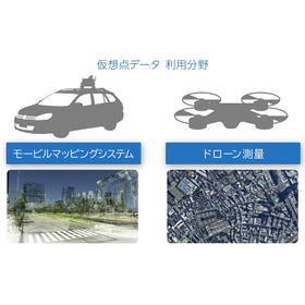
The "Weather Warning Distribution Service" is a service that activates river water level warning units and flooding warning units based on weather warnings issued by the Meteorological Agency. Warnings are distributed to each warning unit via the Unimation System's server, so there is no need for customers to manage the server themselves. Additionally, if warnings from a different municipality are received and the downstream warning is activated, it increases the possibility of preventing accidents caused by river flooding, especially when the upstream area belongs to another municipality. 【Features】 ■ Supports all prefectures nationwide ■ Capable of receiving weather warnings from different municipalities or districts ■ No complicated server management required ■ Low cost ■ Can be implemented with just one warning unit *For more details, please refer to the PDF materials or feel free to contact us.

  • Other Management Services

ブックマークに追加いたしました

ブックマーク一覧

ブックマークを削除いたしました

ブックマーク一覧

これ以上ブックマークできません

会員登録すると、ブックマークできる件数が増えて、ラベルをつけて整理することもできます

無料会員登録

Cloud-based digital content distribution service "Incosnet"

Bulk control via cloud server! No complicated operations are needed with an easy-to-use interface.

"Incosnet" is a cloud-based digital content distribution service that allows for the delivery of video and still image content via the internet. Since the STB (playback device) connects to the cloud through the internet, there is no need for peripheral devices such as servers. In addition to the combination of the STB and display, our service allows for easy operation of content creation, distribution, and management in the cloud, making it possible to distribute content to remote locations. 【Features】 ■ Centralized management of multiple signage from a single PC ■ Scheduling function for content distribution ■ A wide range of optional features ■ Standard content creation functionality ■ Support for various file formats *For more details, please refer to the PDF document or feel free to contact us.

  • Audio and video equipment

ブックマークに追加いたしました

ブックマーク一覧

ブックマークを削除いたしました

ブックマーク一覧

これ以上ブックマークできません

会員登録すると、ブックマークできる件数が増えて、ラベルをつけて整理することもできます

無料会員登録

LINE advertising message creation and distribution service "PLISM"

Easily create messages and send them all at once! LINE advertising messages made incredibly simple.

"PLISM" is a service that allows you to easily create and distribute high-quality LINE advertising messages. By using this service, you can simply select a design template you like and input the necessary information to easily distribute high-quality messages. Additionally, there are design templates with link functions (such as link buttons) that can guide users to your current website, online shop, or product pages, potentially increasing your visit numbers. 【Features】 ■ Supports scheduled distribution with specified dates and times ■ Easy distribution in three steps: select a design, input information, and choose a distribution method ■ Design templates with link functions (such as link buttons) available ■ Can guide users to websites, online shops, or product pages ■ Distribute product information from your online shop via LINE rich messages *For more details, please refer to the PDF materials or feel free to contact us.

  • Email delivery system

ブックマークに追加いたしました

ブックマーク一覧

ブックマークを削除いたしました

ブックマーク一覧

これ以上ブックマークできません

会員登録すると、ブックマークできる件数が増えて、ラベルをつけて整理することもできます

無料会員登録

Various smartphone wallet key distribution services

Finally, electronic locks for accommodations now support Apple Wallet and Google Wallet keys! Business efficiency and guest convenience have also greatly improved!

Modern hotel guests are always seeking convenience and efficiency during their stay. With our latest solution, Apple/Google Wallet Key, you no longer need to worry about whether or not you have a membership app or mobile key compatibility with electronic locks! The introduction of Wallet Key combines hassle-free simplicity with a self-service tool for easy resolution, making it an entirely new DX solution that allows hotels to improve operational efficiency and differentiate their services, while providing guests with the highest level of convenience and customer satisfaction. For the distribution and operation of Wallet Key, we offer two types: an app issuance version that uses existing apps as a trigger, and a web issuance version that delivers keys to wallets via email or SMS. For hotel groups that already have membership apps, we can provide the app issuance version for existing domestic customers, while offering the web issuance version for inbound and walk-in customers, helping to make their stay at the hotel even more comfortable and convenient. Please feel free to contact us.

  • j731n1hv.png
  • mh5a832r.png
  • 4hoiwmfc.png
  • xguro5th.png
  • rvra2fga.png
  • iPhone_14_Pro_Space_Black_Apple_Watch_Series_8_45mm_with-AAGS-card.png
  • Entrance and exit control system
  • Entrance/exit management and personal identification system
  • Security locks (windows, front doors, etc.)

ブックマークに追加いたしました

ブックマーク一覧

ブックマークを削除いたしました

ブックマーク一覧

これ以上ブックマークできません

会員登録すると、ブックマークできる件数が増えて、ラベルをつけて整理することもできます

無料会員登録

Antenna-Free Television Shared Service - Jaynet TV

With one optical fiber line, both WiFi and TV viewing are available!

A video distribution service utilizing optical fiber lines for internet communication, with free Wi-Fi facilities for residents and a comprehensive installation of television equipment! It enables viewing of terrestrial, BS, and CS channels without the need to install a TV antenna, thereby reducing construction costs. Since it is less affected by weather conditions, stable viewing is achieved even on rainy or windy days. *Please note that for BS and CS, residents who wish to view these channels must apply separately.

  • Shared TV reception system

ブックマークに追加いたしました

ブックマーク一覧

ブックマークを削除いたしました

ブックマーク一覧

これ以上ブックマークできません

会員登録すると、ブックマークできる件数が増えて、ラベルをつけて整理することもできます

無料会員登録

Address collection and email distribution service "milmel"

Gather and deliver information via email, simplifying the information collection and distribution process!

"milmel" is an address collection and email distribution service specialized in targeted approaches. It allows for the collection and management of customer information using emails, and you can see the open rates of sent emails and link clicks. Please feel free to contact us when you need our services. 【Features】 ■ Customizable address registration screen ■ Hassle-free address management ■ Guaranteed delivery *For more details, please refer to the related links or feel free to contact us.

  • Other services and technologies

ブックマークに追加いたしました

ブックマーク一覧

ブックマークを削除いたしました

ブックマーク一覧

これ以上ブックマークできません

会員登録すると、ブックマークできる件数が増えて、ラベルをつけて整理することもできます

無料会員登録

High-Precision Cloud Delivery Service "Ara Kantan"

For providing additional information about exhibits that cannot be touched and for online presentations!

This service is a web service that allows for high-speed, high-definition viewing without the need to install an app. You can check a large number of photos, drawings, perspectives, videos, specifications, documents, etc., in a network environment on large touch monitors, smartphones, tablets, and PCs, with fast and high-definition scrolling display. It can also be used for online presentations, allowing viewing without downloads and without leaving data on tablets and other devices. Additionally, it enables enlarged displays of items and artworks that cannot be physically touched, making it easy to provide supplementary information about exhibits. 【Features】 ■ High-speed, high-definition scrolling display ■ Large-capacity data registration on the server ■ Realistic viewing of high-quality content ■ Viewing high-quality content on touch monitors ■ High-speed, high-definition viewer *For more details, please refer to the catalog or feel free to contact us.

  • Sign construction
  • Other Software

ブックマークに追加いたしました

ブックマーク一覧

ブックマークを削除いたしました

ブックマーク一覧

これ以上ブックマークできません

会員登録すると、ブックマークできる件数が増えて、ラベルをつけて整理することもできます

無料会員登録

[Technical Information] Differences Between Virtual Point Method and Surface Correction Method

The virtual point method distributes virtual reference point data! The surface correction method distributes correction information from the reference station!

I will introduce the differences between the "Virtual Point Method" and the "Surface Correction Method." These two methods differ in the content of the data they deliver. The "Virtual Point Method" delivers observation data and correction information from virtual reference points. The "Surface Correction Method" delivers correction information from reference stations and surface correction parameters. *For more details, please refer to the PDF document or feel free to contact us.*

  • Other earthworks, foundation works, and exterior floors
  • Other measuring instruments
  • Surveying

ブックマークに追加いたしました

ブックマーク一覧

ブックマークを削除いたしました

ブックマーク一覧

これ以上ブックマークできません

会員登録すると、ブックマークできる件数が増えて、ラベルをつけて整理することもできます

無料会員登録

[Technical Information] Patent technology for network-based positioning considering crustal deformation.

A patented surveying system! Distributing correction information through real-time data acquisition!

We would like to introduce our patented technology, "Patent Technology Considering Japan's Crustal Movements," in the context of network-based distribution services. Our patented "Surveying System" focuses on the ability to obtain electronic reference point data in real-time and provides correction information that aligns the results of GNSS surveying and positioning with the output values of electronic reference points located near the surveyor. This technology addresses concerns such as "significant variability in positioning results" and "poor reproducibility of positioning" that arise when crustal movements occur. 【Features】 ■ Correction method for virtual reference points and surveying method (Patent No. 5832050) ■ High-quality data distribution considering crustal movements ■ Alignment with the nearest electronic reference point results ■ Distribution suitable for surveying operations "Technical partnership with GNSS manufacturers" *For more details, please refer to the PDF document or feel free to contact us.

  • Other earthworks, foundation works, and exterior floors
  • Other measuring instruments
  • Surveying

ブックマークに追加いたしました

ブックマーク一覧

ブックマークを削除いたしました

ブックマーク一覧

これ以上ブックマークできません

会員登録すると、ブックマークできる件数が増えて、ラベルをつけて整理することもできます

無料会員登録

Multi-GNSS Demonstration Experiment (Hokkaido Area) [Case Study Introduction]

GNSS maintains FIX solutions longer than GPS alone, and the recovery speed from FLOAT solutions is fast, benefiting from the larger number of satellites!

Our company receives real-time data from electronic reference points provided by the Geospatial Information Authority of Japan at the Genoa Center, conducting analyses 24 hours a day, 365 days a year, and offering high-precision positioning correction data distribution services to our customers. In Bitoe, Tobetsu Town, Ishikari District, Hokkaido, we conducted a demonstration experiment of network-type RTK-GNSS using three electronic reference points: Atsuta, Sapporo, and Eniwa. 【Static Observation】 - Using GLONASS tends to result in less variation compared to using GPS alone. - It was confirmed that using GLONASS during the preparation phase speeds up initialization. - Variability in data occurs during satellite switching (when the number of satellites decreases) for network-type RTK-GNSS observation values. 【Mobile Observation Experiment】 - When using GLONASS, many satellites are acquired, making it less likely to enter a FLOAT solution state. - It was confirmed that even when in FLOAT solution or standalone positioning, the speed of returning to FIX solution (initialization) improves. - It was confirmed that FIX solution is maintained even in environments where satellites are difficult to receive at consistently low elevation angles. - The quick recovery from FLOAT solution was also demonstrated. *For more details, please refer to the PDF document or feel free to contact us.

  • Other earthworks, foundation works, and exterior floors
  • Other measuring instruments
  • Surveying

ブックマークに追加いたしました

ブックマーク一覧

ブックマークを削除いたしました

ブックマーク一覧

これ以上ブックマークできません

会員登録すると、ブックマークできる件数が増えて、ラベルをつけて整理することもできます

無料会員登録

High-precision, high-quality network RTK distribution service

Galileo data distribution has started! A higher fix rate enables stable high-precision positioning, achieving improved productivity!

Our company provides a service that receives and analyzes real-time data from electronic reference points released by the Geospatial Information Authority of Japan, delivering high-precision positioning correction data. We have also started distributing satellite data from the EU's satellite positioning system "Galileo." By adding "Galileo" (with 3 to 7 satellites over Japan) to the conventional GPS+GLONASS+QZS, we can ensure the necessary number of satellites and DOP for RTK positioning even in environments with many obstacles, significantly improving the Fix rate. ◆ Feature 1: DOP is secured 1. A low degradation factor continues. 2. A good satellite configuration lasts longer. 3. Data stabilizes. ⇒ Can be used with confidence! ◆ Feature 2: Fix rate increases 1. The duration of Fix increases. 2. Good accuracy can be received for a longer time. ⇒ Can be used with confidence! *For more details, please refer to the PDF document or feel free to contact us.

  • others

ブックマークに追加いたしました

ブックマーク一覧

ブックマークを削除いたしました

ブックマーク一覧

これ以上ブックマークできません

会員登録すると、ブックマークできる件数が増えて、ラベルをつけて整理することもできます

無料会員登録

High-precision and high-quality Genoa GNSS positioning correction service

Contributing to significant improvements in work efficiency and cost reduction in various fields that require high-precision positioning through the use of real-time data from electronic reference points! Also compatible with public surveying!

Our company receives real-time data from electronic reference points provided by the Geospatial Information Authority of Japan at the Genova Center, conducting analyses 24 hours a day, 365 days a year. We offer a high-precision positioning correction data delivery service to our customers using a virtual reference point method. By utilizing our services, there is no need to install and manage physical reference stations, significantly reducing work efficiency, labor, and management costs. The measurement results are processed using our unique correction method (Genova method), achieving high-precision positioning that complies with public surveying standards. 【Features of the Delivery Service】 ■ Virtual reference point RTK and electronic reference point RTK are also available ■ Compatible with GPS, GLONASS, Galileo, and QZS ■ Aligns with the results of the nearest electronic reference point (Patent No. 5832050) ■ Generates GNSS data using a high-density network of electronic reference points (utilizing approximately 1,300 points nationwide) ■ No need for the installation and management of reference stations, enabling observations by a single person.

  • Other measuring instruments
  • IoT
  • Other civil engineering works

ブックマークに追加いたしました

ブックマーク一覧

ブックマークを削除いたしました

ブックマーク一覧

これ以上ブックマークできません

会員登録すると、ブックマークできる件数が増えて、ラベルをつけて整理することもできます

無料会員登録

Centimeter-level positioning service! High-precision GNSS network-based RTK.

High-precision positioning and location data using GNSS! Utilized in surveying, ICT construction machinery, drones, smart agriculture, automobiles, robots, and more.

Our company, a specialist in location-based services, provides high-precision positioning and location information at the centimeter level by sending corrected data using the electronic reference points from the Geospatial Information Authority of Japan (GSI) for location information observed via GNSS (GPS, GLONASS, Galileo, QZS). The data is transmitted over the internet, allowing for real-time location information requests. ■ We have created a video about our business, so please take a look ■ https://www.jenoba.jp/movie.html 【Main Use Cases】 ■ Public surveying, land and house surveys ■ Construction work and project management using ICT construction machinery (i-Construction) ■ Surveys, inspections, and logistics using drones and UAVs ■ Unmanned agriculture using ICT agricultural machinery ■ Autonomous driving, etc. 【Features of the Distribution Service】 ■ Network-based RTK service using virtual reference points ■ Compatible with GPS, GLONASS, Galileo, and QZS (Michibiki) ■ Aligns with the results of the nearest electronic reference points (Patent No. 5832050) ■ No need for the installation and management of physical reference stations

  • Other civil engineering works
  • IoT

ブックマークに追加いたしました

ブックマーク一覧

ブックマークを削除いたしました

ブックマーク一覧

これ以上ブックマークできません

会員登録すると、ブックマークできる件数が増えて、ラベルをつけて整理することもできます

無料会員登録

Case Studies on the Use of Network RTK: UAVs and Drones

Introducing use cases of "network-type RTK" in the UAV and drone field.

This document introduces examples of the use of a unique technology (JENOBA method) that utilizes real-time data from electronic reference points in the field of UAVs and drones with a "network-type RTK." [Published Examples] ■ Application in Firefighting Robot Systems (From the Fire Research Center, National Fire Academy) *For more details, please refer to the catalog or feel free to contact us.

  • Other measuring instruments
  • Specially equipped vehicles

ブックマークに追加いたしました

ブックマーク一覧

ブックマークを削除いたしました

ブックマーク一覧

これ以上ブックマークできません

会員登録すると、ブックマークできる件数が増えて、ラベルをつけて整理することもできます

無料会員登録

PPK, leave the post-processing analysis to us! Genova's post-processing data distribution service.

Distributing reference station data (RINEX data) used for PPK and post-processing analysis in GNSS positioning! Utilized in MMS, aerial surveying, and drone surveying.

Satellite positioning can be performed independently without using network communication, and by analyzing the observed data along with reference station data (RINEX data) using post-processing analysis software, high-precision location information can be obtained. Regarding reference station data, there is no need for the physical installation of reference stations; it can be obtained through a method that virtually generates data at specified coordinates (virtual points) or by downloading it from designated electronic reference points provided by the Geospatial Information Authority of Japan. ■ A video explaining "virtual point data" in an easy-to-understand manner is available here: https://www.jenoba.jp/movie3.html 【Main Use Cases】 - Public surveying, land and property surveys - Surveys (measurements) and inspections using drones and UAVs - Aerial surveying - Mobile Mapping Systems (MMS) - 3D map creation 【Features of the Distribution Service】 - High-precision positioning is possible without network connection on-site - No need for the installation of reference station facilities - Data from the past six months can be obtained at one-second intervals - "Electronic reference station data" and "virtual point" data are available; by specifying nearby reference station locations for virtual point data, even higher precision positioning can be expected.

  • Surveying Office
  • Other measuring instruments
  • Other civil engineering works

ブックマークに追加いたしました

ブックマーク一覧

ブックマークを削除いたしました

ブックマーク一覧

これ以上ブックマークできません

会員登録すると、ブックマークできる件数が増えて、ラベルをつけて整理することもできます

無料会員登録